
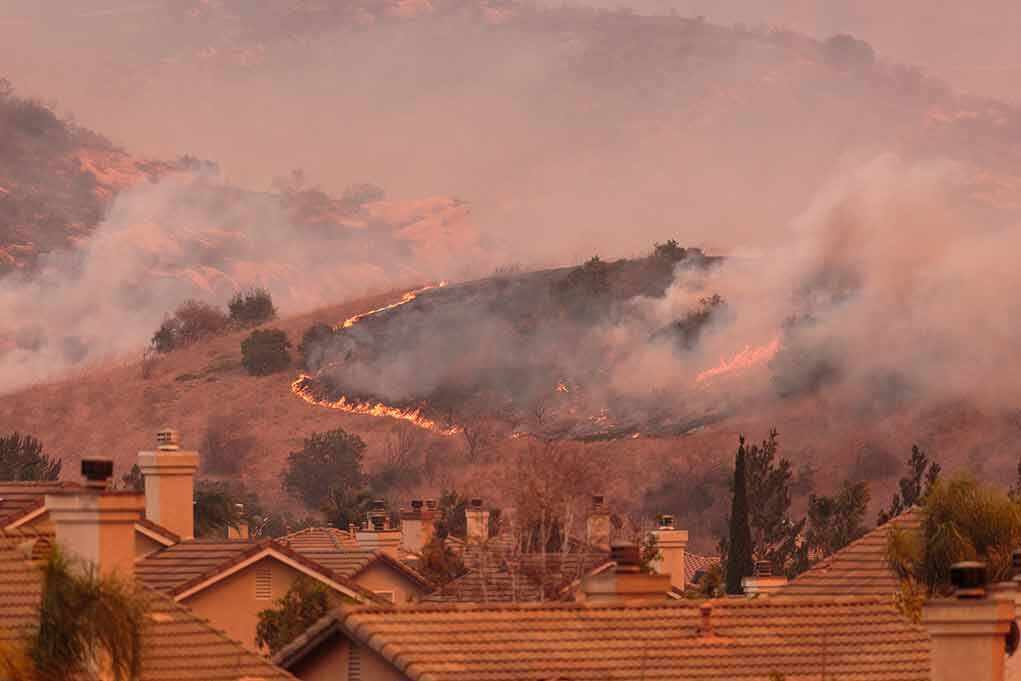
Before-and-after images from the sky turned Spokane’s worst burn scars into irrefutable street maps of loss.
Story Snapshot
- Aerial photos and satellites reveal block-by-block wildfire damage across Spokane County.
- Nearmap captured neighborhoods before June 13 and after August 1 as flames overran streets.
- Planet Labs satellites showed fresh burn scars forming between July 31 and August 2.
- Evacuations and hundreds of destroyed structures matched what the images display on the ground.
What the Images Show, and When They Showed It
Nearmap’s aerial photographs captured a clean baseline on June 13, 2026, then a stark update on August 1 as the Old Trails Fire pushed into Spokane County neighborhoods. The side-by-side frames match streets, roofs, and tree lines with striking precision. Entire rows of homes shift from intact to ash in a matter of blocks. Reporters described hundreds of destroyed homes and firefighters staged at intersections, a scene that aligns with the new imagery’s time stamp and detail.
Planet Labs satellites caught the wider signature. Images from July 31 and August 2 bracket the burst of burn scars on the city’s edge, with fresh blackened polygons spreading across the hills and into subdivisions. The consistency between the tight, low-altitude Nearmap frames and the broad, orbital views adds weight. Different platforms, different angles, but the same neighborhoods, the same losses, and the same timeline.
How We Know the Pictures Fit the Fires
Geostationary weather satellites watched ignition and growth in near real-time on August 1. The National Oceanic and Atmospheric Administration’s GOES-West feed flagged active fire pixels as the Old Trails Fire advanced, lining up with the hours when Nearmap flew and recorded neighborhoods in peril. Local and national outlets then verified locations by matching road grids, cul-de-sacs, and landmarks across the pairs. This method is simple, fast, and strong when the patterns converge across sources.
The numbers that officials and newsrooms reported track with what the imagery implies: hundreds of structures destroyed, with multiple fires damaging the metro fringe and nearby towns. The heat signatures, the plume tracks, and the burn scars slot together like a puzzle. When independent sensors agree on where and when, common sense says you trust the overlap first and argue edge cases later.
Why Aerial and Satellite Proof Matters to the Public
Disasters scramble attention and fuel rumors. Clear pictures cut through that noise. Side-by-sides help families grasp which blocks stand and which do not, and help officials plan street closures, patrols, and utility shutoffs. The same visuals also let taxpayers judge response priorities. That is not “disaster porn”; it is public oversight. Transparency earns trust, and trust drives compliance when evacuations and checkpoints decide who lives and who does not.
Washington State
SMOKEY SKIES
Explosive wildfire activity spreads smoke across Washington
Satellite imagery of smoke plumes over Washington and Oregon, with active wildfires marked by orange dots.
By WA State Dept. of Ecology
August 4, 2026Current situation
Multiple… pic.twitter.com/kg9Xgnh7Jc
— S.A. Dupres (@Susan_Dupres) August 4, 2026
Some critics argue that images can mislead if dates or alignments are fuzzy. That caveat is fair in theory. Here, the timestamps, cross-outlet matches, and corroborating satellite fire detections address that concern. The result looks like a textbook case of rapid visual verification done right: consistent dates, matched features, and outcomes that fit official damage counts and evacuation orders on the record. That is the standard citizens should expect every time.
What Comes Next, and What to Watch
Recovery teams will keep using these datasets to map debris zones, spot hazards, and route heavy equipment. Insurers and public adjusters will use the same frames to confirm total losses and speed checks, which matters when families face weeks in hotels. Investigators may compare heat signatures and wind shifts to trace fire spread paths and jump points across the river and ridges that shielded Spokane’s north side—until they did not. Expect more detailed perimeters as flights and passes stack up.
Sources:
youtube.com, instagram.com, facebook.com, bbc.com, weather.gov
© targetliberty.org 2026. All rights reserved.